Not released yet · Android first
Built for the roads with no signal
RiderStorm is a touring companion for motorbike riders in India. Record your rides offline, plan trips with the fuel gaps in view, find the stays, fuel and puncture shops other riders have marked, and let your family follow along. It rewards exploring, never speed.
Join the waiting list See what it does
The app is in development and not in the Play Store yet. Android comes first, iPhone after. People on the waiting list hear first.
Concept designs. The app is in development, and screens may change.
Who it is for
For riders who tour, not riders who race.
The weekend run up a ghat, the yearly trip to Ladakh or Spiti. Solo or with a few friends, on whatever you ride, and often far past the last bar of signal.
Offline first
The best rides have no signal. Recording, maps, markers and saved routes all work with no network at all, and your rides upload when you are back in range.
Exploring, never speed
No speed anywhere, not even an average. Rides count distance, riding time, climb and the highest point you reached. No leaderboards, ever.
Safety is free
SOS, Call 112 and the live link for your family are free for every rider, always. They are never behind a paywall.
Private by default
Your rides are private unless you publish one as a route. Privacy zones keep where you live and work out of anything you share.
Record
Record every ride, even with no signal
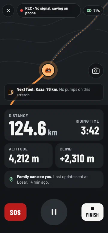
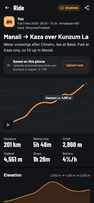
Start a ride and put the phone away. RiderStorm keeps recording with the screen off and saves everything on the phone, then uploads the ride when you are back in signal.
- Distance, riding time, climb and highest point. No speed of any kind.
- Take photos while you ride, pinned to the place on the map.
- Following a route? The next fuel stop is on the screen.
- Afterwards, the ride with its elevation profile and photos.
Concept designs. The app is in development, and screens may change.
Maps
Maps that keep working in the mountains
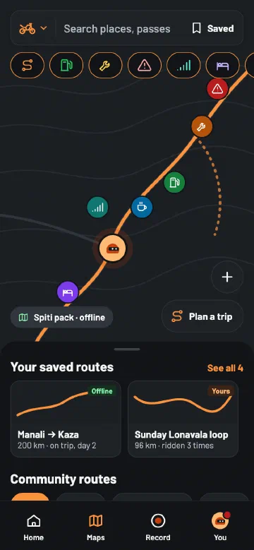
Download a region’s map on Wi-Fi before you go, and it works with no signal at all: the roads, the markers and your saved routes. Every region is free.
- Show fuel, repair shops, stays, cafés, dhabas, road alerts and the last places with mobile network.
- Search passes, towns and villages inside the maps you have downloaded.
- When you are online, open a route in Google Maps for turn-by-turn directions.
Concept designs. The app is in development, and screens may change.
Community
What other riders have marked, and the routes they rode
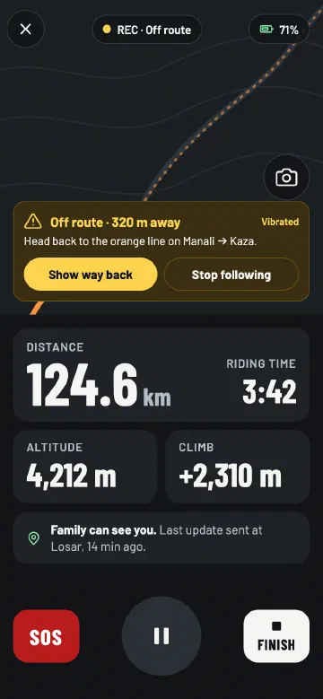
Stays, fuel and repair shops start from OpenStreetMap, and riders add what is missing, from dhabas to road alerts, even offline. You can confirm a marker is still there or flag it when it is not, and road alerts expire after 7 days unless someone confirms them again.
- Publish your ride as a route, with its start and end trimmed so it does not show where you live.
- Browse routes by region, save them for offline, and follow one on the map.
- Drift off the line and the phone warns you, with the way back.
Concept designs. The app is in development, and screens may change.
Trip planner
Plan the trip, and see the fuel gaps first
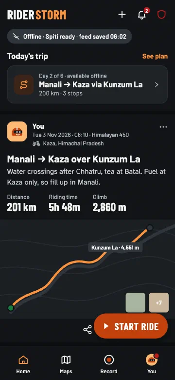
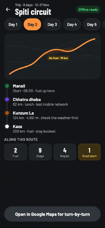
Plan a trip from a start, an end and the stops in between, or start from a saved route. RiderStorm shows what lies along the way, and warns you where the fuel stations are far apart.
- Fuel, stays and repair shops near the route, with how far along the way they are.
- A warning for long stretches without fuel, and the last places with mobile network.
- Make the whole trip available offline in one tap.
Concept designs. The app is in development, and screens may change.
Safety, free for every rider
Your family knows where you are
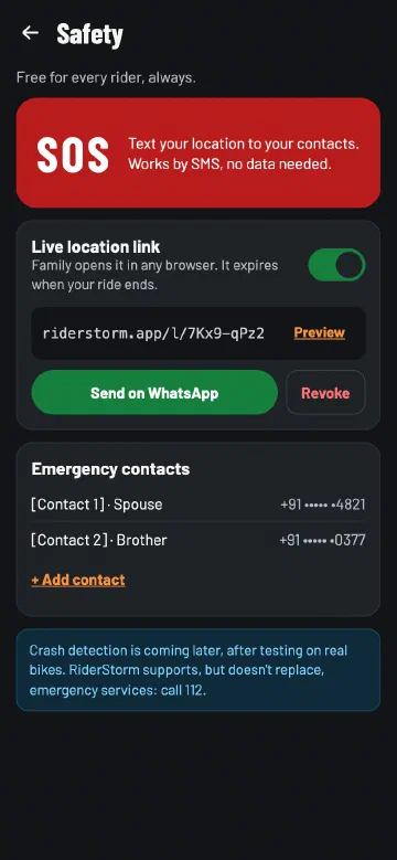
Safety is never behind a paywall. Add your emergency contacts once, and it is all one tap away while you ride.
- SOS opens one text message to your contacts with your last known location, ready to send. It works by SMS, with no mobile data.
- Call 112 in one tap, with the nearest repair shops from the offline map.
- Live link: a private link your family opens in any browser. It shows where you are and the nearest village, and stops working when the ride ends.
RiderStorm supports emergency services, but does not replace them.
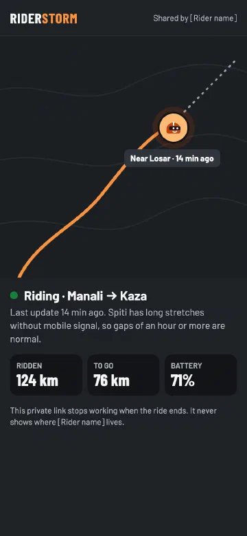
Concept designs. The app is in development, and screens may change.
Share
Share the ride, not the speed
Every ride makes a card for WhatsApp and Instagram: the route line, the distance, the highest point and the riding time, with one of your photos if you like.
- The Road Passport stamps ten great passes and ghats when you ride them, from Khardung La and Kunzum La to Amboli Ghat.
- Your week in distance, riding time and climb, and up to five bikes in your garage.
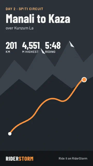
Concept designs. The app is in development, and screens may change.
Launch regions
Where it starts
The first maps cover three regions, with markers and routes from riders who know them. More regions follow.
High passes
Ladakh
Union territory of Ladakh
Khardung La, Chang La, Umling La and the road over Zoji La.
High passes
Spiti and Lahaul
Himachal Pradesh
Kunzum La, Rohtang and Baralacha La, and the long stretches between fuel stops.
Weekend rides
Western Ghats
Maharashtra, Goa and Karnataka
Amboli, Malshej and Tamhini Ghat, and the weekend runs from Mumbai, Pune and Goa.
What it is not
RiderStorm is not a racing app: no speed, no lap times and no leaderboards. Its first version is for you and your own rides. Following other riders, clubs and group rides come later.
Questions
Good to know
When will the app be available?
There is no date yet. The app is being built and tested on real rides now. People on the waiting list hear first when it is ready.
Android or iPhone?
Android first, because that is what most riders in India use. iPhone comes after.
Does it work without signal?
Yes, that is what it is built for. Once you have downloaded a region’s map, recording, the map, the markers and your saved routes all work with no network. SOS works by SMS. Your rides and markers upload when you are back in signal.
What will it cost?
SOS, Call 112 and the live link for your family are free for every rider, always, and so are the maps of the launch regions. Anything else will be clear before the app is released.
Can I ride with my club or follow friends?
Not in the first version, which is for you and your own rides. Following riders, clubs and group rides come later. You can already invite friends on WhatsApp, share your ride cards and publish routes for other riders.
Which languages?
English first. Hindi and other Indian languages come later.
What happens to my email address?
We email you once to confirm it, and it is on the list only after you open the link; if you never do, it is deleted automatically. After that it is kept on our own server, used only to tell you about RiderStorm, and deleted when you ask. The details are on the Privacy page. Questions: [email protected].
Be the first on the road with it
Join the waiting list and confirm your address from the email we send you. We will email you when the app is ready for Android, and perhaps once before that to ask what you need from it.
Check your email.
We've sent you a link to confirm your place on the list. Open it to finish: you're not on the list until you do. It can take a few minutes, so look in your spam folder too.